Maps, drawings and plans by Richard Bartlett (Barthelet) and others,
1587-1625.
A collection of manuscripts maps of Ireland, mostly by cartographer Richard Bartlett (Bathelet) circa 1602. Includes maps and plans for towns and fortifications in various counties, including Armagh, Cork, Leitrim, Monaghan, Tyrone and Waterford. It also contains plans of structures such as Dublin Castle and maps depicting military emcampments during the Nine Years War.
Saved in:
Show/hide more info.
| Main Creator: | |
|---|---|
| Contributors: | |
| Format: | Manuscript |
| Language: | English |
| Subjects: | |
| Notes: | Physical description: 22 items. |
| Arrangement: | Fonds. |
| Access: | Originals withdrawn. Digitised images are available online. |
| Published / Created: |
1587-1625.
|
Loading...
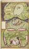
Drawing of Dungannon Castle and the stone chair at Tullaghoge, Co. Tyrone,
circa 1602.
| In Collection: | Maps, drawings and plans by Richard Bartlett (Barthelet) and others, 1587-1625. |
|---|---|
| Description: | The lower half of this image is a depiction of Dungannon Castle and surrounding settlements, plus the stone chair at Tullahoge and surrounding areas. The upper half of this picture shows an attack on a crannog in an unspecified location. |
| Main Creator: | |
| Created: |
circa 1602.
|
| Language: | English |
| Extent: | 1 sheet : 25 x 41 cm. |
| Format: | Manuscript |
| Call Number: |
MS 2656 (5)
(Manuscripts Reading Room) |
| Access Conditions: | Original withdrawn. Digitised images are available online. |
| Rights: | Reproduction rights owned by National Library of Ireland. |